Mapping History:
The Ever-changing Face of
Cartography
Are you fascinated by the intricate science and art behind creating maps? Cartography is the field that brings us the incredible power of maps, providing us with valuable insights about diverse places and their characteristics. From understanding terrains to predicting weather patterns and exploring unique cultures, maps serve as invaluable tools for navigating our world. Join us on an exciting journey as we delve into the captivating realm of cartography together

Photo by Lara Jameson
ANCIENT CARTOGRAPHY
The history of cartography stretches back to the dawn of human civilization, an awe-inspiring journey that we’re about to embark on. Imagine ancient cultures sketching their surroundings on cave walls or etching maps onto stone and tusks -an ingenious testament to their quest for understanding and navigation. From the great civilizations of Babylon, Greece, Rome, China, and India, maps emerged as invaluable tools, shaping our perception of the world.

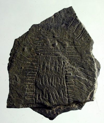
“Landscape Stones” on the island of Bornholm in Denmark (Bornholm Museum/Skalk Magazine)

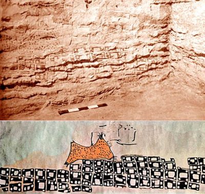
Çatalhöyük city map with the eruption of Mount Hasan volcano, ca 6200 BC (Yerinde Çizer)
However, these early maps fell short of representing the Earth’s curvature accurately. It wasn’t until Classical Greece that an innovative approach emerged. Visionaries began mapping larger regions using projections derived from model globes, enabling a more faithful depiction of our planet. This technique allowed cartographers to control distortion and achieve greater precision.
As time progressed, technological advancements propelled cartography forward. During the Age of Exploration, maps became indispensable for intrepid sailors venturing across uncharted seas. In the crucible of World War II, maps became vital instruments of military strategy, guiding troops across complex battlegrounds.
As cartographers honed their craft, they incorporated increasingly advanced techniques and equipment. Compasses and telescopes became indispensable tools, unveiling new dimensions of the world’s mysteries. Then, a leap into the skies brought aerial photography and satellite imagery, revolutionizing our understanding of Earth’s landscapes—truly awe-inspiring!

Photo by PhotoMIX Company
Today, we are privileged to access a wealth of digital mapping resources. Platforms like Google Earth and other free online services offer an unprecedented opportunity for armchair explorers to traverse every corner of the globe from the comfort of their own homes. It is a testament to the remarkable progress we’ve made.
Yet, let us not forget the remarkable, storied history of cartography. From ancient maps etched onto clay tablets to cutting-edge GPS systems, humans have tirelessly endeavored to chart the Earth’s expanse since the inception of civilization. It reminds us of the
significance of understanding our place in space and time.
DIGITAL CARTOGRAPHY
With the rapid advancement of technology and sophisticated mapping tools at our fingertips, the world has become a vast playground awaiting exploration. Today, we invite you to embark on a captivating journey into the realm of digital cartography, where precision and convenience intertwine seamlessly.
Digital cartography, an intriguing technology, empowers us to create virtual maps utilizing spatial data. This revolutionary process, often referred to as digital mapping, offers a precise representation of diverse areas while emphasizing key locations and routes. While we commonly associate digital cartography with in-vehicle navigation systems like GPS, these dynamic maps find their way into numerous computer applications. Their versatility proves indispensable in navigating unfamiliar terrains and embarking on exciting adventures.
Through digital cartography, we gain access to detailed and accurate maps that enhance the quality of our lives in countless ways.
Whether we’re planning an epic road trip or simply seeking guidance through an unfamiliar city, these maps become our invaluable companions, guiding us with unparalleled ease and reliability.
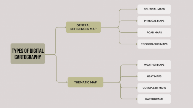
Types of digital cartography
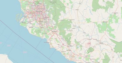
- General reference maps, also known as base maps, serve as widespread public resources displaying both natural and man-made features of general interest.

West Coast area of Malaysia (OpenStreetMap)
- Thematic maps have specific purposes, such as displaying selected demographic or scientific data based on a theme. They are commonly created using GIS applications and involve analysis

Thematic Maps Of San Diego Housing (Caliper Corporation
Type of General Reference Maps
- Political maps: Depict boundaries, cities, and other man-made elements. Useful for understanding counties, countries, and significant cities.
- Physical maps Emphasize geographical characteristics like rivers, elevation, deserts, and more. Ideal for teaching, urban planning, and travel.
- Road maps: Detailed maps designed for drivers or travelers, focusing on intersections and roadways. Paper maps are being replaced by digital maps with real-time updates and voice instructions.
- Topographic maps: Highlight the elevation of the Earth’s surface using contour lines or color gradients. Include political aspects, names of geographical features, and serve purposes such as resource exploitation, planning, and hiking.
Type of Thematic Maps
- Weather maps: Familiar maps presenting global weather information, including precipitation, wind, temperature, and fronts. Many people often consult weather maps as part of their morning routines to plan their days.
- Heat maps: Show temperatures across a map, using colors or shading to represent temperature extremes. These typically appear in weather forecasts during freezing spells and heat waves.
- Choropleth maps: Display colors in specific areas to communicate the occurrence of a variable. Useful for election outcomes, technology diffusion, or density ratios.
- Cartograms: Resize map areas to represent the number of features, such as population. While effective in portraying statistics, understanding maps is necessary to appreciate a cartogram.

CONCLUSION
The captivating history and modern innovations of cartography have revealed the profound impact of maps on our lives. From ancient civilizations sketching on cave walls to the cutting-edge technologies of digital cartography, humans have always sought to understand and navigate our world. Today, we stand at the forefront of a digital revolution where precision and convenience converge in spatial data and virtual maps.
As we embrace the future of cartography, let us continue to honor and learn from its storied past. Together, we can unlock the full potential of digital cartography, navigate the complexities of our world, and shape a more sustainable and interconnected future. Join us on this remarkable journey of discovery and exploration. The possibilities are limitless, and the adventure awaits!

Photo by Mikhail Nilov